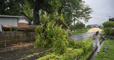
Typhoon Shanshan Approaches Japan, Bringing Heavy Rain and Winds
Typhoon Shanshan was barreling toward southwestern Japan on Tuesday, bringing torrential rain and strong winds, forcing some flight cancellations and disrupting the country’s high-speed rail network.
The powerful storm had sustained wind gusts of up to 120 miles per hour on Tuesday, equivalent to a Category 3 hurricane, according to the U.S. Navy’s Joint Typhoon Warning Centre.
As the typhoon approaches the Amami Islands, an archipelago southwest of Japan’s mainland, it is expected to dump up to 16 inches of rain on the islands on Tuesday, the Japanese Meteorological Agency said. Later in the week, parts of western Japan may receive nearly two feet of rain within 24 hours. The agency warned of the potential for widespread floods and landslides.
After approaching the Amani Islands, the storm is predicted to shift north on Wednesday and approach Kyushu, one of Japan’s main islands, by Thursday. It may make landfall in Kyushu, the agency said.
Because the typhoon is moving slowly, the Amami region and western Japan will experience long periods of violent or very strong winds and rain, the agency said.
Winds of up to 90 miles per hour were forecast in southern Kyushu and the Amami region starting from Tuesday, and could increase to 110 miles per hour on Wednesday.
Japan Airlines said that it had canceled some Wednesday flights arriving and departing from parts of central Japan, including from Osaka Kansai Airport, one of the country’s biggest airports. All Nippon Airlines, the country’s largest airline, said that the storm was expected to affect some flights at Osaka airport.
The country’s high-speed rail network, the Shinkansen, began to cancel some services starting Tuesday. The cancellations may last until the weekend,


