Satellite imagery shows scale of devastation after Papua New Guinea landslide
CNN —
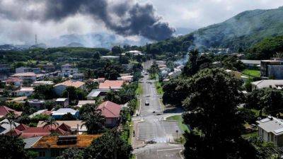
Images from the air and the ground have revealed the huge breadth of the devastating landslide that has left as many as 2,000 people buried under rubble in Papua New Guinea.
Satellite imagery from before and after the landslide show a vast section of the landscape in the mountainous Enga region essentially torn away.
A satellite image shows a closer view of a hillside before the landslide in Yambali village, Enga Province, Papua New Guinea, June 27, 2023. Maxar Technologies/Handout via REUTERS THIS IMAGE HAS BEEN SUPPLIED BY A THIRD PARTY. NO RESALES. NO ARCHIVES. MANDATORY CREDIT. MUST NOT OBSCURE LOGO. A satellite image shows a closer view of the landslide in Yambali village, Enga Province, Papua New Guinea, May 27, 2024. Maxar Technologies/Handout via REUTERS THIS IMAGE HAS BEEN SUPPLIED BY A THIRD PARTY. NO RESALES. NO ARCHIVES. MANDATORY CREDIT. MUST NOT OBSCURE LOGO. Satellite images show the landslide in Yambali village, Enga Province, Papua New Guinea. Maxar Technologies/ReutersThe vast size of the slide is even more visible from nearer the ground. More than 150 houses in Yambali village were buried in debris, officials said Sunday. The country’s National Disaster Center said almost 2,000 were feared to be buried.
The landslide hit the remote village of Kaokalam, about 600 kilometers (372 miles) northwest of the capital Port Moresby, at approximately 3 a.m. local time on Friday (1 p.m. Thursday ET), leaving a scar of debris that humanitarian workers said was as big as four football fields.
The landslide essentially tore away a huge swathe of the mountainous landscape.The phenomenon slammed tons of rock and mud into locals’ homes as they slept, and rescuers struggled to reach such a remote part of what
Related News