Philippines’ use of Canadian system to track Chinese ship signals Ottawa’s interests
The Philippine coastguard said the satellite system, launched after Manila and Ottawa signed a memorandum of understanding last year, had boosted the Philippines’ ability to track China’s activities and was key in safeguarding Manila’s maritime domain even as adversarial vessels turned off their location-transmitting devices.
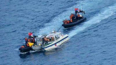
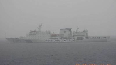
Philippine coastguard spokesman Commodore Jay Tarriela on Thursday reported the tracking of activities by Beijing’s 13,000-tonne coastguard ship – nicknamed “The Monster” – over the last 10 days. The vessel moved close to El Nido in Palawan, the Philippine island facing the South China Sea, at one point.
“It directly encroached upon the territorial waters of the Philippine-occupied features, of Parola and Pagasa, violating our sovereignty,” Tarriela said, adding the vessel was later detected on the Philippine side of the Spratly archipelago and possibly resupplied for logistics before continuing on its voyage, including into the exclusive economic zones of Malaysia and Brunei.
The Philippine coastguard said the vessel continued moving through the region before heading towards El Nido and maintained a close distance of 34 nautical miles from its coastline.
“From there, it made a quick turn towards Bajo De Masinloc [Scarborough Shoal], where it joined three other China coastguard vessels that were deployed in the area. After spending a few hours loitering at the shoal, the ship sailed back towards Hainan,” Tarriela said.
In 2012, China gained control of Scarborough Shoal, a traditional fishing ground, after a stand-off with the Philippines, and the area has seen bouts of high-tension encounters over sovereignty and fishing rights for years.
Canada has been supporting Manila’s position in its maritime
Related News